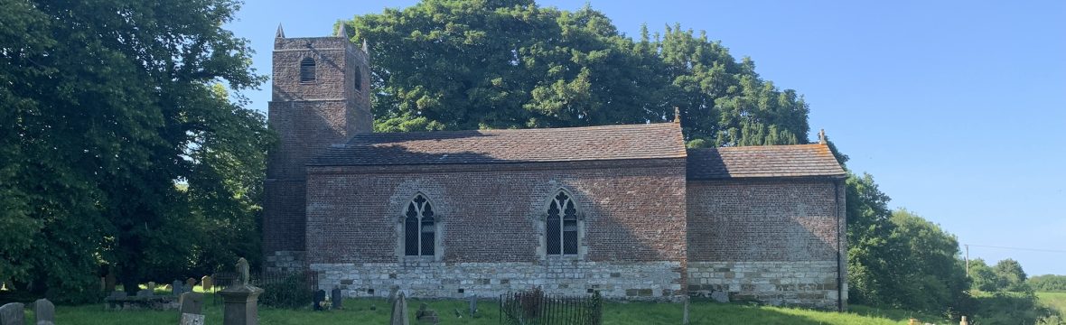
Hanby, a deserted mediaeval village
Hanby was a village mentioned in the Domesday survey of 1086 associated as an outlying dependency of Welton le Marsh. The village disappeared in 1348 when the population perished from the Black Death or moved away as it was no longer a viable community. All that remains today is the site of a moated motte-type castle (opinion varies whether this is of Celtic or Norman origin) and the moated enclosure of Hanby Hall. Whilst there are no visible remains of the village, it is commemorated by the name of the adjacent road, Hanby Lane and a Victorian poem recording the battle of Hanby in 1643.
Origins of the village
Roman greyware pottery has been found in the fields suggesting that the village existed at least two thousand years ago. Flint tools can also be found in these fields, but subject to dating may have been left by passing Mesolithic hunter gatherers or could be the site of a Neolithic farming community.
A visit to Hanby Hall site
Some of the following information is referenced from the Genealogy site of Nadine Hamby who visited the area in 2015. https://nadinehamby.me/the-hamby-family-of-buncombe-and-yancey-counties-england/hanby-hall-farm. More information and pictures can be seen at that site.
Name of Hanby village
The name ‘Hamby’ came from Hamby, now Hanby, a hamlet in the parish of Welton Le Marsh (Welton-on-the-Marsh) in Lincolnshire, England. The name Hamby means Hundi’s farm in old Norse/Danish. The ‘m’ and ‘n’ were interchangeable. The site in Lincolnshire, where the original motte and bailey castle stood, still has the remains of a moat. The large manor, known as Hanby Hall or Hanby farm, was probably built around the 14th century.
The following is from Historic England/Pastscape:
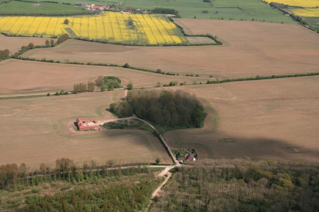
The lost village of Hanby was represented by Hanby Hall, an ancient farm-house surrounded by a moat within which foundations of earlier buildings have been traced. Hanby Hall which stood within a manorial moat. In the NE corner of the moated area are the remains of associated fishponds. About 300 yards from Hamby Hall is a large tumulus or barrow, called Castle Hill, “which is supposed to be of Celtic origin.”
The moat now encloses the island on two sides. The eastern moat arm was infilled and ploughed in late 1988 or early 1999. The northern arm and north eastern corner of the moat lay to the north of the present track, in an area now under cultivation and are no longer evident. The extant sections of the moat measure up to 10m in width and 1m deep in places and now serving as a drainage ditch.
A series of outbuildings were located to the north west of the the Hall and obscured the north western corner of the moat. The Hall was demolished together with the surrounding outbuildings leaving one extant group of buildings, part of Hanby Hall Farm, to the north west of the moat.
Other cropmarks in the vicinity indicate boundaries, enclosures and the remains of ridge and furrow. The area is now under cultivation and only slight earthwork remains of the square enclosure are now visible.”
The following is from Castle Hill: a motte castle from Historic England.
Motte castles are medieval fortifications introduced into Britain by the Normans. The monument includes the earthwork and buried remains of a medieval motte castle, known as Castle Hill, located 250m east of Hanby Hall Farm. In 1086 land at Welton le Marsh was held by Gilbert de Gant, and during the 13th century, by Jolanus de Hamby. The motte is associated with the medieval manor of Hanby.”
This is an 1889 map of the area from Old-Maps.co.uk. The current large U shaped building appeared before 1950.
Origin of the personal name of Hanby
The Humbys and Humbies all probably take their name from two places in Lincolnshire. Great Humby is recorded in Domesday Book as Humbi. Ekwall proposed that the specific might be a Scandinavian personal name Hundi, and I accepted this suggestion in 1968, but there is no certain evidence for the existence of this personal name in the Danelaw and I therefore suggested in 1978 that the specific might be a
topographical appellative húnn in a sense such as ‘block, clump’. Now, however, I am more inclined to treat it as a form developed from the genitive plural of the appellative hundr ‘dog’, on analogy with some of the forms considered as being of this origin in the name Hanby. This was borne by a hamlet on the edge of the marshes in the parish of Welton le Marsh in Candleshoe Wapentake. It is recorded in Domesday Book as Hundebi (351va), Hunbia (351vb) and Hūnbi (375rb) and in the Lindsey Survey as
Hunbi (20). Later forms recorded by the EPNS are Hambia c.1150, Hundeby 1201, 1210. The name survives as that of Hunby Hall in the first edition of the one-inch Ordnance Survey Map in, I think, the form, Hunby Hall, but clearly as Hanby Hall on the 7th series map. The name is not treated in Cameron’s popular dictionary. I suggested in 1978 that the explanation of both Hanby and Humby may be that dogs were kept there. I became more certain about this when I looked at the entries for the Humbies in Scotland, where Humbie in West Lothian is recorded in 1290 as Hundeby, while the earliest form for Humbie in East Lothian is c.1250 Hundeby (Macdonald 1941: 42). All of which seems to show that settlers looking for suitable names for new assarts in Scotland centuries after the end of the Viking Age seemed to be perfectly happy to choose a name in -bý without having any clear conception of the semantic significance of the name or of the site or sites bearing the name in England. https://www.nottingham.ac.uk/research/groups/epns/documents/journal/49-2017/jepns49-2017-cameronlecture-5-40.pdf

Disappearance during the black death
https://www.lincolnshirelive.co.uk/news/local-news/revealed-100-plus-medieval-lincolnshire-3463235
Modern-day Lincolnshire is the sort of sparsely-populated place where you can travel for miles without meeting a single soul. Out in the countryside, away from Lincoln and the major towns and villages, it can seem like an endless succession of fields, a few houses, and winding roads. However, up until about the 1300s, parts of rural Lincolnshire, particularly the Wolds, were among the most densely-populated areas of medieval England. The countryside was once brimming with farms, monasteries, wealthy estates, hamlets, villages, manors houses as recorded in the Domesday Book of 1086. But places with wonderful sounding names like Beasthorpe (near modern-day Owersby, Market Rasen), Helethorpe (near Fulnetby), Tatebi (near Ulceby in East Lindsey) and Wolmersty (near Friskney) have quite literally disappeared off the face of the Earth. Or in many other cases villages shrunk in size, for example an area of land to the south west of modern Nettleton, near Caistor, has gone forever.
How many villages have been lost?
There are more than 130 known deserted medieval villages listed on the Lincolnshire Historic Environment Record of archaeological sites and historic buildings collated by Lincolnshire County Council. And in many cases, all that remains is a pond, a moat or a narrow track or archaeologists have found burials or the foundations of manor houses. Twenty burial sites discovered by metal detectorist near east coast A good example is Biscathorpe, in the Lincolnshire Wolds, where the land still bears the ridge and furrow marks of medieval ploughing. Theories as to why settlements vanished include climate change and the Black Death. The overriding reason was probably economic as landowners sought to maximise profit through sheep farming.
So just why were they abandoned?
Richard Watts, senior historic environment officer (records), who manages Lincolnshire’s database of deserted medieval villages, said it’s not strictly accurate to lay the blame solely on the Black Death. He said: “The reasons why a settlement would have been abandoned are many and varied – while a common perception is that the villages were abandoned due to the Black Death, this is actually quite rarely the correct reason. “The Black Death and other plagues often had a significant effect, but a large proportion of these sites had actually already been deserted before the illnesses even hit, or were deserted many years after when the effects had largely passed.” Mr Watts added that it was all about the money. He said: “The generally accepted reason for the desertion of the majority of these sites is usually economic. England was a major producer and exporter of wool during the medieval period, and the raising of sheep was one of the biggest industries here at that time. Essentially, raising sheep was far more profitable than growing crops, and many landlords converted their arable villages to pastoral sheep farms, kicking the vast majority of the village’s inhabitants out, thus abandoning most the settlement. Sheep required a relatively small workforce to look after, while growing crops was very labour-intensive, especially at times of ploughing and harvesting.”
How do we know? The Luttrell Psalter
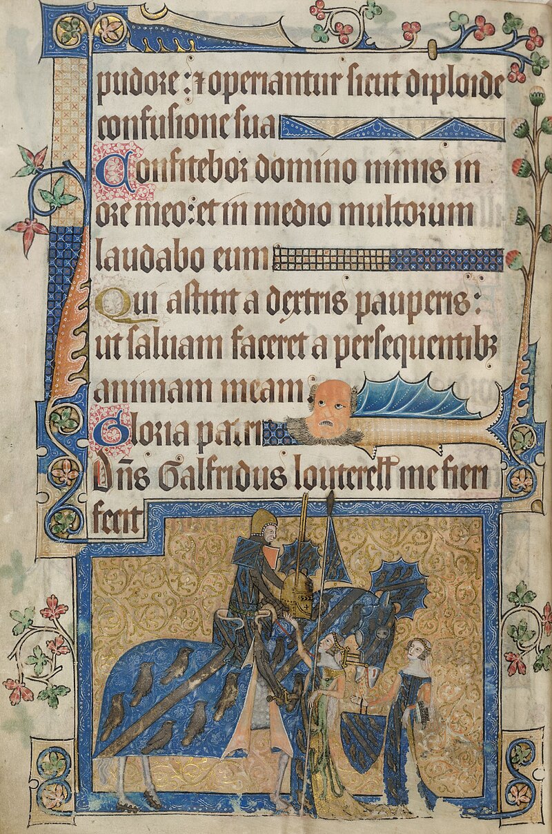
A book produced in Lincolnshire in about 1325 to 1340 gives a fascinating contemporary glimpse of life in medieval times. The Luttrell Psalter is an illuminated manuscript commissioned by Sir Geoffrey Luttrell, who was lord of the manor of Irnham, near Grantham. It contains Bible stories and scenes of rural Lincolnshire including farming, cooking and children playing. We can see the sort of clothes they wore and how they lived their lives. The book was brought to life in 2006/7 in a film by Lincolnshire-based Crow’s Eye Productions, with scenes shot in a recreated medieval village in Wales, built from the foundations of an original deserted settlement.

very interesting. Thank you for your very detailed research. I shall share with interested parties.
LikeLike